First Winter Snow of 2021 Expected Tonight in Bozeman Area
The National Weather Service has issued a Winter Weather Advisory for the Bozeman area from 5 p.m. tonight (Monday) until Tuesday at 9 a.m. Up to 5 inches of snow is expected to fall in the local mountains, while the Gallatin Valley is expected to get around an inch.
Snow is expected to start after midnight, but it will be a quick storm as it's expected to be moving out of the area by 8 a.m. on Tuesday. Temperatures will be down around freezing through the overnight.
If you are traveling tonight, snow and blowing snow is expected with winds gusting in some areas up to 35 mph. Look for diminishing visibility and slippery roads if traveling over any of the mountain passes. For the latest road conditions call 5-1-1.
Other areas in southwest Montana that are under the Winter Weather Advisory are Beaverhead, Central and Southern Lewis and Clark, Madison, Jefferson, and Gallatin Counties.
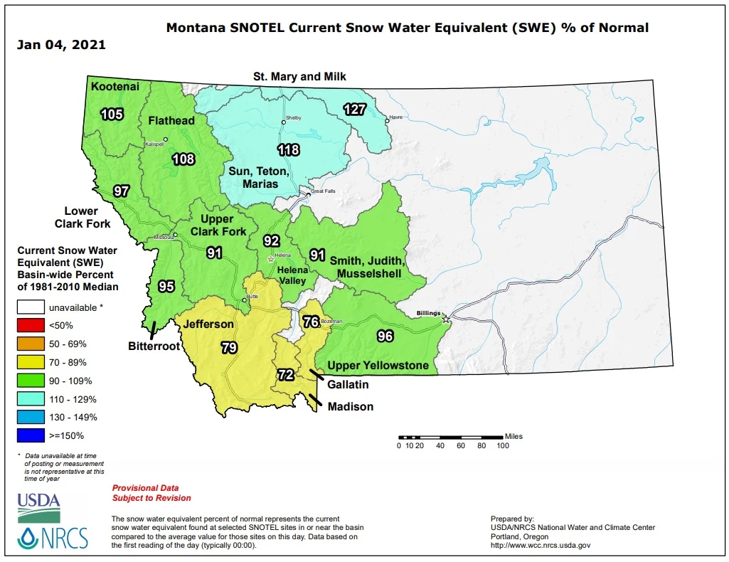
The snow will be a relief as our current snowpack in the local mountains is below normal for this time of year. According to the National Weather and Climate Center, Bozeman's local mountains are at 76% of normal.
While snow has been in short supply in southwest Montana, the northern part of the state is above 100% of normal, with the Havre area as high as 127% of normal.
After this storm tonight moves out of the area, Bozeman expects to have partly cloudy skies for Tuesday and Wednesday with highs near 40. There is a chance of show on Thursday, but less than one inch of accumulation is expected.
KEEP READING: Get answers to 51 of the most frequently asked weather questions...
More From 100.7 KXLB